 City residents have the best broadband, right? Everybody knows it’s just rural residents who are getting left behind, as Internet providers roll out their state-of-the-art fiber optic networks to compete with the cable companies for all those lucky urban customers. Right?
That’s the conventional wisdom. But the FCC’s latest National Broadband Map data tells a different story about who has access to fiber in Ohio.
It turns out that majorities of dwelling units in the cities of Columbus, Cleveland, Toledo, Akron, Canton and Youngstown still don’t have fiber Internet service available.
These six communities have AT&T as their historic telecom provider, or “ILEC”. Adding AT&T’s other large Ohio central city, Dayton, to this list brings the average percentage of residential units with access to fiber broadband across all seven cities to just 41%.
It’s been more than ten years since AT&T began upgrading parts of its Ohio network to fiber. But according to the Broadband Map, nearly three-fifths of dwelling units in the most “urban” communities in the company’s service area are still waiting for it.
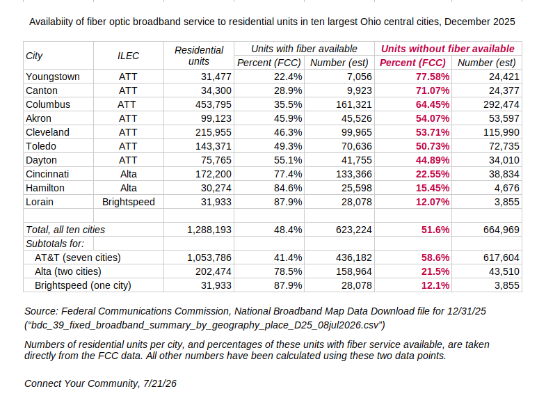 Ohio’s other three “top 10” central cities — Cincinnati, Lorain and Hamilton — are served either by by Alta Fiber (formerly Cincinnati Bell) or Brightspeed (formerly CenturyLink). The percentages of housing in these cities with access to fiber service are significantly higher than those served by AT&T.
But even with those better-served communities averaged in, the new FCC data says fiber broadband is currently available to fewer than half of all housing units in Ohio’s ten most populous central cities.
________________________________________________
Where we got this: The FCC releases an updated version of its National Broadband Map twice a year, based on data from broadband Internet providers for each June 30 and December 31. The most recent Map was released on July 8. Its data is represented to be current for December 31, 2025.
Among the Broadband Map’s “Data Download” files are summary lists of available broadband technologies and speeds for a wide variety of geographic entities, including “places” (cities, villages, other localities). They include the total number of residential units in each place as calculated by the people managing the Map, and the percentage of these units where each Internet technology (cable, fiber, satellite, wireless, DSL, etc.) is reported to be available from some provider, broken out in six different speed tiers. (If you’re curious, the data looks like this.)
We downloaded the FCC’s new summary file for places in Ohio, and excerpted the numbers of total residential units and the percentages of those units served by fiber broadband, at speeds of at least 100 Mbps down and 20 Mbps up, for the ten cities listed in the chart above.