 We’ve updated our statewide map showing the percentages of households without subscriptions to wireline Internet service (cable, DSL or fiber) for all Ohio Census tracts.
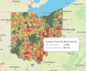
The new map shows data from the 2020-2024 American Community Survey 5-Year Estimates, released by the U.S. Census in January. As with earlier versions, we’ve color-coded Census tracts on a scale from red (60-100% of households in a tract without wireline Internet) to green (less than 20%). Point your cursor at any tract to display a pop-up showing the county name, the tract number, and the number and percentage of households without wireline connections. The map is fully interactive, and there’s a full-screen link near the bottom right corner (next to the “share” symbol).
(Unfortunately the embedded “live” map isn’t displaying properly on phone screens yet. So if you’re reading this on your phone, sorry — you’ll need a computer to check it out.)
Click on the thumbnail above or on this link to go to our updated map page.